The general question for this entry is: How do you measure
an earthquake?
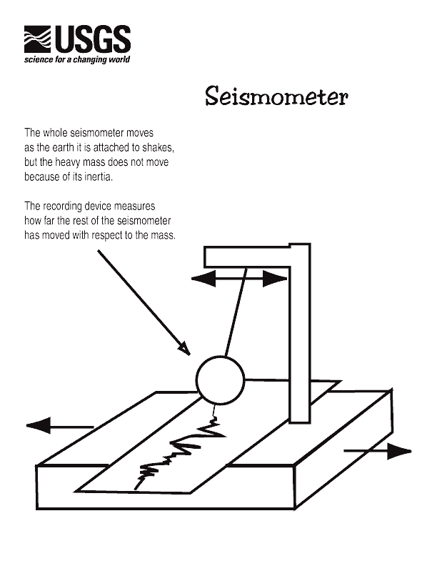
For the majority of measuring methods, we must use a seismograph. A seismograph is essentially an ink pen on a ball which is attached to the ground by either springs or wire. As the land moves with the earthquake, the ball will sway and ink draws out the shape and direction of ground movement. The paper produced by seismographs look something like this:
Once the seismograph has drawn a line, the result will usually look like this:

If you read the previous entry, you will be familiar with each type of wave. As we can see, the smaller body waves arrive first and then the larger surface waves. The timing between each wave is usually quite short but intense (ie 5/120 seconds, the duration of the earthquake), as we are concerned with earthquakes that are from Ecuador.

(Sourced from http://www.geo.mtu.edu/UPSeis/reading.html)
If you read the previous entry, you will be familiar with each type of wave. As we can see, the smaller body waves arrive first and then the larger surface waves. The timing between each wave is usually quite short but intense (ie 5/120 seconds, the duration of the earthquake), as we are concerned with earthquakes that are from Ecuador.
Now with this explained, we can talk about the Richter scale.
You probably have heard of the Richter scale when measuring
earthquakes. This is simply a measure of the maximum surface wave height (see diagram) measured against the distance from the source of that
earthquake. This done by using the time between the arrival of the first P-wave and the first S-wave is used to
work out this distance by using the graph. This will give us a value of 1-10, the numbers we are
used to seeing when talking about earthquake magnitude. This scale is logarithmic, which in essence means a magnitude 7 earthquake is ten times stronger than one of 6, which is ten times bigger than one of 5 etc. A way to think of it is like when a doctor asked you to rate your pain on a scale of 1- 10 if you are more than 6 then take cover as your insides must be collapsing.
A Richter Scale diagram looks like this:

A Richter Scale diagram looks like this:

(Source http://www.bgs.ac.uk/discoveringGeology/hazards/earthquakes/MeasuringQuakes.html)
As we can see from this diagram, the amplitude is the measure of the highest recorded wave (in this case 20mm) measured against the distance (or the S-P wave lag time of 25 seconds). These results are measured in a straight line from each other and from this we can clearly see it this is a magnitude 5 earthquake.
However there is are problems with this method. The main problem with using the Richter scale is that it becomes inaccurate at high magnitudes. Also as seismographs are a relatively recent invention, there are no records of historical earthquakes using this method (ie there are no Richter scale records of earthquakes before the 20th century).
Nowadays there is more complicated and more accurate method of measuring the size of an earthquake of higher magnitude; The moment magnitude. To do this out you need to work out the seismic moment. The seismic moment of an earthquake is the combination of how much the land is moved by the earthquake or the displacement of land, the area that was moved and the strength/stiffness of rocks in the affected area (for example you can get weaker rocks, like sandstone that are not very stiff). The process of working out the moment magnitude from this are far too complicated to be covered in this blog but if you are interested click this link https://earthquake.usgs.gov/learn/topics/measure.php.
Now, the method which you can be a part of and help scientists work out the magnitude/ severity of the earthquake is the Mercalli Scale. Don’t be intimidated by the name, it is rather simple. It is a scale that is simply someone's perception of how intense the earthquake is. It is measured from I (one) to XII (12). This figure should explain it better;

(Taken from http://dnr.mo.gov/geology/geosrv/geores/richt_mercali_relation.htm)
This is a good short term method of measuring an earthquake. However, it can be a bad measurement of an earthquake's size. For example the scale is from a person’s point of view, so it might change from person to person.
This is a good short term method of measuring an earthquake. However, it can be a bad measurement of an earthquake's size. For example the scale is from a person’s point of view, so it might change from person to person.
#Quaketips 2
No comments:
Post a Comment